


The Garmin GPSMAP 840xs is part of the brand new series of fishfinders from Garmin that have the capability of down imaging as well as side imaging. In this model, down imaging is built in while side imaging needs the GCV-10 unit which can be purchased separately.
This fish finder features a big 8 inch color display and comes pre-loaded with LakeVu Maps as well as BlueChart G2 coastal maps.
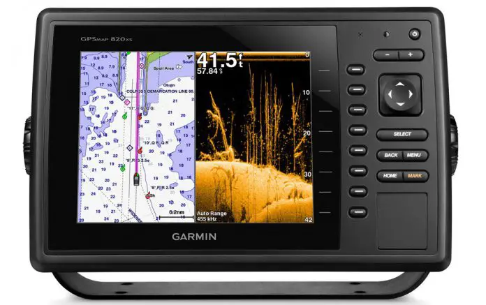
Combining Garmin DownVu and the advanced 77/200 kHz HD-ID together with CHIRP technology and an all in one transducer, the GPSMAP 840xs makes for an ultimately stunning photographic view of what is under the boat.
Garmin GPSMAP 840xs

On the GPS side of things, the GLONASS receiver/built in GPS will update your position and direction 10 times per second. The sonar recording capability enables one to time the sonar return with the boat’s position and provide valuable SONAR maps of your favorite fishing spots.
You can also connect wirelessly to Apple iOS devices via the BlueChart mobile software. In addition, it’s compatible with both Bluechart g2 Vision and LakeVu HD Ultra.
The device comes with a 500W, dual beam 77/200 kHz, transom mounted transducer that is able to support DownVU, CHIRP and traditional broadband sonar. Other transducers including the 1000W 50/200 kHz dual frequency transducer and 600W CHIRP transducers are supported too, and can be bought separately.
CHIRP enhances the capturing of the most details, resulting in crystal clear outputs even at very high speeds. One is able to suppress sonar noise so as to achieve an incredible target resolution while getting to greater depths. With the GPSMAP 840xs, you can go for a maximum depth of 1750 feet when using the 500W Garmin dual frequency transducer, and a depth of 2700 feet when using the 1kW Airmar B260 transducer.
The in-built LakeVu cartography caters for 17,000 U.S lakes. Its GPS has a refresh rate of 10 kHZ which translates to a virtually fluid display and is also Garmin Radar compatible. The 840xs offers the NMEA 2000 support which is a great feature allowing for connection with other devices such as SiriusXM Weather radar and autopilot to keep one updated on changing weather conditions.
The Garmin CHIRP technology makes the device a top notch gadget. It’s able to display crystal clear sonar images with sufficient details on fishing hot spots, diving locations or ship wreckages.
At extraordinary depths, you can attain an outstanding target resolution and separation, with specific frequencies dialed so as to target certain species of sport fish. The contours at the bottom are more visible, even at greater speeds, and signal noise can be inhibited to provide a more accurate interpretation of what is below hence better fishing and safer navigation.
The device also features dynamic sea temperature levels. A huge range for sea temperatures can be set as it dynamically adjusts to display a color range targeting specific types of fish. The device also accommodates radar support, in which one can make a choice of marine radar, be it open array or the xHD dome radar that enables the use of advanced open array features.
The 840xs also supports special sailing features which include laylines, course-over and heading ground lines, enhanced wind rose, true wind data fields coupled with time/tide/current slider.
The gauge displays are designed to provide crucial need-to-know information at a glance, including the apparent wind angle, true wind speed, set and drift, horizontal or vertical graphs and a data bar coupled with customizable data fields.
It is also compatible with a smartphone or tablet from which one can view and control the device. The Garmin Chartplotter allows for compatibility with an iPhone or iPad, or any phone or tablet using Android.
This comes in handy when providing situational awareness for the mariner. For mounting preferences, one can easily switch from portrait to landscape modes. With use of an iPhone or iPad, one can easily record a chartplotter screen movie to share with friends and family. The Garmin chartplotter can be downloaded from Google Play or the App store.
The device does support an enhanced auto guidance feature. The Garmin Auto guidance technology is great feature, when one enters the location where he or she wants to go, it searches through relevant charts to create a safe pathway on display that helps one avoid shallow water, low bridges and other charted obstructions en route.
At the end of the day, the Garmin GPSMAP 840xs is a truly all in one device that can serve as the main control center for your boat.


 of Atlantic salmon identified")


